north shore maps
for places along minnesota’s north shore of lake superior
Do you like a good visual? Want a map to show you the lay of the land? We’ve got that for you. We have maps for hiking, biking, climbing, camping, the Superior Hiking Trail, the Gitchi-Gami State trail [paved], cross-country skiing, alpine skiing and snowboarding, snowmobiling, snowshoeing and fat bike trails. Plus a full map from Duluth to the Canadian border.


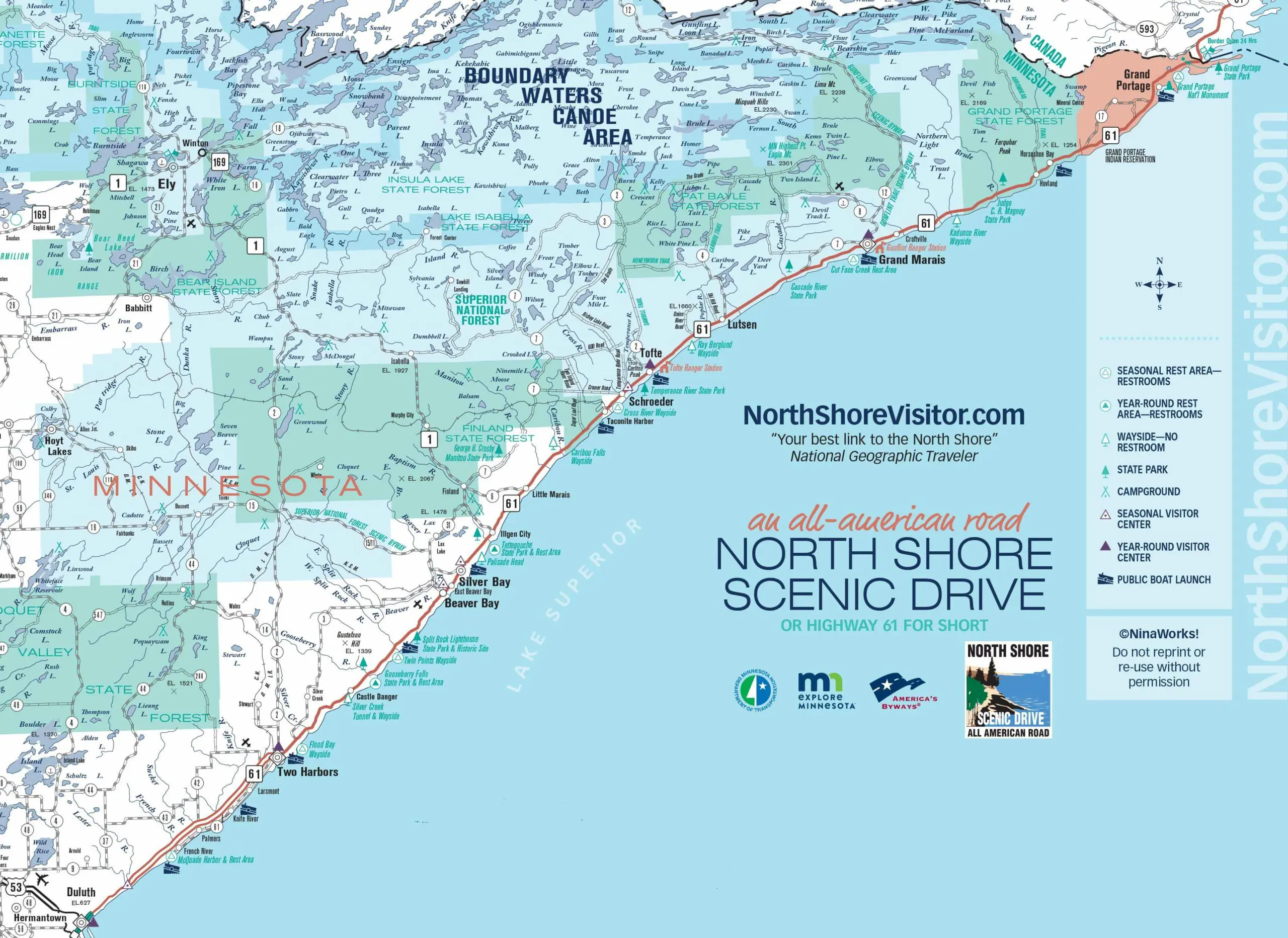
From Duluth’s Canal Park, northeast for 154 miles to Grand Portage and the border with Canada, this singular drive is a voyage through some of America’s most unspoiled lands. Your route offers breathtaking views, endless opportunities to enjoy nature, historic sites, attractions, parks, and villages with events, shopping, lodging, dining, and local culture.
The path hugs the water’s edge along the inland coast of the world’s largest freshwater lake, bisecting the shore and the ancient inland rock formations and wooded hills rising above the coast. The North Shore Scenic Drive was recognized for the outstanding scenic and recreational opportunities it provides along the touted North Shore of Lake Superior and was designated as an All-American Road, Minnesota’s only such designation.
Watch for varying speed limits along Highway 61 – it varies from 55 mph to 65 mph plus slow areas through towns and state parks
2026 updates
new! Moose Viewing Map
Use the filter below to see and download the new moose viewing map (note the driving directions are on the map)

use this filter to find north shore maps!
mile 0.0
mile 0.0
mile 0.0
Find a Lake Superior Agate
This map highlights North Shore agate beaches, showing you the best places to find Lake Superior agtes.mile 0.0
mile 0.0
Explore North Shore Waterfalls
Find and explore the best North Shore waterfalls. This map marks waterfalls near Duluth MN and along the North Shore MN.mile 5.0
mile 5.0
mile 5.2
mile 14.9
mile 16.0
mile 23.2
mile 24.8
mile 26.2
Walk, Ride or Roll along the Sonju Trail Two Harbors
This North Shore MN map showcases the paved waterfront Sonju Trail in Two Harborsmile 27.5
mile 27.5
mile 27.8
mile 36.8
mile 39.0
Park Map with Hiking [including Superior Hiking Trail] Mountain Biking, paved Gitchi-Gami State Trail, and camping
mile 39.0
Ski, Snowmobile & Snowshoe Trails Park Map
mile 39.0
mile 39.5
Superior Hiking Trail - Gooseberry to Split Rock
This map highlights the Superior Hiking Trail from Gooseberry to Split Rock Lighthouse with parking and camping.mile 39.5
mile 39.5
mile 43.5
mile 43.6
mile 46.0
Walk the lakeside Little Two Harbors Trail
The Little Two Harbors Trail at Split Rock Lighthouse State Park winds it way along Lake Superior including a cobblestone beach with turnaround views of the lighthouse.mile 46.0
Fat Bike, Snowshoe, & Winter Hiking Trails Park Map
mile 46.0
Split Rock Lighthouse State Campground Map
This handy map shows the Split Rock Lighthouse campground map; the campground is located in the state Park a bit inland from Lake Superior.mile 46.0
mile 46.0
mile 50.3
Superior Hiking Trail - Beaver Bay to Silver Bay
This map highlights the Superior Hiking Trail from Split Rock Lighthouse to Beaver Bay to Silver Bay with parking and camping.mile 53.5
mile 54.0
mile 54.0
mile 54.0 +20
mile 55.2
mile 58.5
mile 58.5
Baptism river & Lake Superior cart-in campground maps
mile 58.5
Maps of rock climbing locations at Tettegouche State Park
mile 60.0
mile 68.0
mile 68.0
mile 69.4
mile 70.7
mile 73.3
mile 78.8
mile 80.4
mile 80.4
mile 80.4
mile 82.2
mile 82.4
mile 82.5
mile 83.4
mile 83.4
mile 84.2
Hiking Trail & Access Map
mile 86.1
mile 86.6
mile 87.3
mile 90.0
mile 90.5
mile 92.2
Hiking Trail & Access Map
mile 92.8
mile 99.6
mile 99.8
mile 99.8
mile 107.3
mile 108.9
mile 109.1
Kayak route and lake access map
mile 109.2
Hiking Trail & Access Map
mile 109.2
mile 109.2
mile 109.2
mile 109.2
gunflint mile 3.2
gunflint mile 6.5
mile 110.5
gunflint mile 14.8
gunflint mile 25.0
gunflint mile 43.6
gunflint mile 42.4
gunflint mile 25.0
gunflint mile 28.0
gunflint mile 41.6
mile 114.5
Hiking Trail & Access Map
mile 118.8
Hiking Trail & Access Map
mile 123.8
Hiking Trail & Access Map
mile 123.8
mile 123.8
Hiking Trail & Access Map
mile 130.8
Hiking Trail & Access Map
mile 132.8
Hiking Trail & Access Map
mile 150.8

Check out these North Shore Favorites