white lettering on orange background northshorevisitor.com com logo
Search
Close this search box.
Search
Close this search box.
have a picnic north shore

My Favorite Picnic Spots on the North Shore

Smoked fish from the big lake next to the big lake, yes please.

Fresh pastries and a latte on Lake Superior, I’m in.

Snacks and a refreshing libation while listening to the waves wash ashore, sounds good to me.

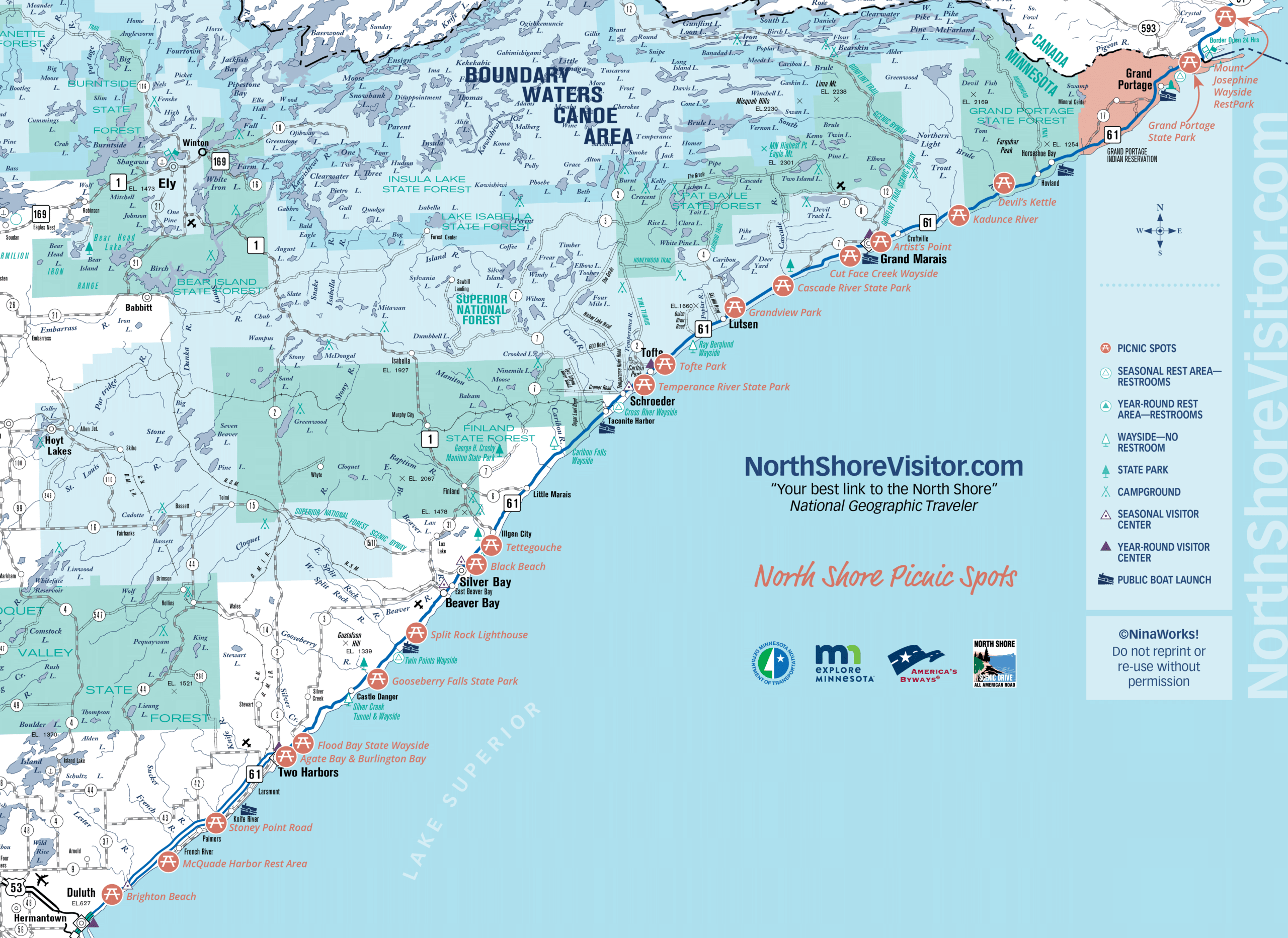
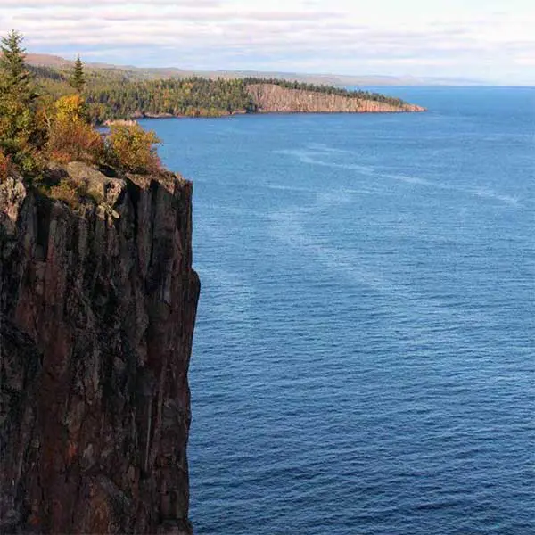
Food plus nature is a mighty fine combination in my book. Especially if there is a light breeze or bit of campfire smoke to keep bugs at bay. In lieu of that, I recommend bringing bug spray and a blanket, towel, cloth to sit on. You can pack a cooler or make a few stops and put together an impromptu meal. Be sure to use one of the bags for trash [if the receptacles are full, take it back home/to your lodging]. 

Help keep the North Shore looking pristine, please dump your trash and recycling at a designated location.

North Shore Picnic Maps

mile 5.2

Part of Kitchi-Gami park; Brighton Beach is perfect for skipping stones, agate-hunting, ship-watching, wading, picnicking and lollygagging. Features summer-use restrooms, picnic tables and grills. Brighton Beach starts just past the little blue tourist info center and runs 0.8 miles to Scenic 61/Congdon Blvd.

Note North Shore beaches are pebble or cobblestone; for sand, head to Park Point In Duluth.

Brighton Beach Road is closed to traffic as improvements to the park and shoreline are underway. To access, park at the visitor center parking near the mouth of the Lester River or a small parking area on Scenic 61.
mile 15.8

Stoney Point Scenic Drive is a brief one-mile dirt road edging Lake Superior off Scenic Highway 61. It is ideal for wave-watching on stormy days, lake gazing and relaxing on calm days, and picnicking. You will find public access to the big lake toward the east end of the road.


mile 26.2

Walk from Agate Bay near the iron ore docks along a 1-mile paved walkway, the Sonju Trail, to Burlington Bay.

Agate Bay attractions include the Edna G tugboat, the Railroad Depot museum,  the Two Harbors Lighthouse museum and gift shop, and working ore docks – watch ships enter the harbor, dock and load up with pellets. Skip stones, picnic and search for agates along the cobblestone beach of Burlington Bay.

wintry ski in ski out townhomes at caribou highlands lodge at lutsen mountains
mile 39.5

For many this is the first big stop on their travels.  This four-season park offers accessible trails to rushing waterfalls, plus trails through the woods, along the river and to Lake Superior; naturalist programs, biking, fishing, fall colors, birding, skiing, plus shopping, exhibits, restrooms, and visitor info in a firelit lobby within the Visitor Center.

mile 46.0

Split Rock Lighthouse is the most well-known visual representation of the North Shore. Have you been? The Lighthouse, part of the MN Historical Society, offers a guided tour of the lighthouse, fog-signal building, oil house and lightkeeper’s house. The visitor center has gifts, exhibits and a brief video. Each November 10th, the beacon is lit at the Edmund Fitzgerald Memorial.

The adjacent state park has trails, camping, and alluring forests running down to the shoreline.

clearwater historic lodge on gunflint trail northern lights
mile 58.5

Spread over 9300 acres, Tettegouche is a handful of overlapping parks including Lake Superior coastline, Baptism River and falls, inland lakes, hardwood forests, rugged topography PLUS 24/7 restrooms, a café and gifts, and charming fireside indoor and outdoor seating. Something for everyone!

mile 80.4

Amazing river gorges that start a few feet inland from the highway, waterfalls, two foot-bridges, hiking, a cobblestone river mouth, camping and hiking. Hike a short way upriver to the amazing gorges, then return south of the highway and walk across the foot-bridge. During spring runoff or after rainy days, the river spray will mist you. Back in the day, this was the only river without a [sand] bar at the mouth, hence the name, Temperance.

mile 82.4
tri-colored cobblestone bridge at tofte park on lake superior

See the Handmade Cobblestone Well and Bridges

Tofte Park

Located on a quiet piece of Lake Superior shoreline, Tofte Park is a lovely spot for a picnic, a party (you can rent the space!), or hanging out watching the waves. Tucked behind the Tofte Post Office and Firehall, the park is noted for its two cobblestone bridges and a cobblestone wishing well that once was offered spring fed water. Take a closer look: the bridge has red, white and blue-grey cobblestones, brought in by fishing boat from nearby Schroeder in the early 1900s.

The park has a short paved path, an open log pavilion, picnic area, small playground and access to Lake Superior. Park land was donated by Elizabeth Tofte, the eldest daughter of original European settlers John and Cecilia Tofte. As she was still a minor, her father had to act as her legal representative. Her mother donated land for the nearby Zoar Lutheran church. And now we all get to enjoy it!

Nearby

Bluefin Bay Resort | Temperance River State Park | Britton Peak | Town of Tofte

mile 99.8

Cascade brings the river to you. A quick jaunt up well-maintained trails brings you to overlooks and a footbridge spanning the cascades. This is an ideal photo spot.

Picnic spots are a quarter mile farther along Highway 61. If you want to ski over the river and through the woods, Cascade has amazing cross-country skiing. Feel free to snowshoe anywhere, too.

mile 103.9

Heading northeast, just past Thomsonite Beach, Highway 61 curves left, revealing picturesque Good Harbor Bay, Seagull Rock, and, in the distance, Grand Marais. Use the pull off to admire the view and take photos. A quarter mile farther is Cut Face Creek Wayside, a nice spot for a picnic, an agate search, and skipping stones.

mile 109.6

Artist’s Point is the island and tombolo, a spit of land, that makes up the east side of the harbor, including the east breakwall and lighthouse; a drop of wilderness in the lake. So inspiring! Find picnic tables along the East Bay’s cobblestone beaches.

mile 118.7

Relax, skip stones, and picnic on the beach. The there-and-back hike follows the Kadunce River with spurs to overlooks and pools. During the warm months of summer, when the water runs low, many locals hike up the river, including climbing the waterfall.

mile 123.8

The popular hike runs cliffside high above the Brule River. After a spur to the Lower Falls, make the final climb to where the splits. The eastern flow tumbles over the High Falls while the western arm drops into the Devil’s Kettle, final destination unknown. The hike is within Judge C.R. Magney State Park.

mile 150.8

It’s all about hiking to the 120-foot High Falls, but leave time for the exhibits, gift shop and interpretive signs in and around the Visitor Center, where you can learn about the culture and traditions of the Grand Portage Ojibwe people. Bring your camera.

Access to Grand Portage State Park is Free!

State Park Vehicle Permits are NOT required at this park.

mile 27.5
flood bay state wayside

Walk the Beach

Flood Bay State Wayside offers a nice long pebble beach. Amble, search for agates, wade, picnic, relax. The walkway to the beach goes through a wetland that is sometimes home to waterfowl, otters, and beavers. Offers a seasonal restroom.


mile 146.6

The Mount Josephine Wayside Rest has a spectacular overlook with views of the Susie Islands below in Lake Superior and Isle Royale in the distance. Isle Royale National Park is part of Michigan. The area is open April through October, has picnic tables and outhouses, and is located on the lake side of Highway 61.

Looking for a place to dispose of your picnic waste? Waysides and parks may have a bin. If you need to find a recycling or waste disposal center check out the links below

sparkling wintry lake superior and ice sheets stacked on north shore

Get North Shore travel tips delivered to your inbox