white lettering on orange background northshorevisitor.com com logo
Search
Close this search box.
Search
Close this search box.
hiking trail in the woods at split rock lighthouse

north shore hiking trails

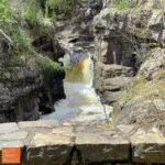
The North Shore has magnificent hiking! North Shore hikes range from an amble up a river, admire cascades, cross the river and return to your car in a half-mile (Cascade River), hike the 310-mile Superior Hiking Trail [S.H.T.] and any length in between. This is an ideal way to observe both the vastness of Lake Superior and the detail of wildflowers, geologic formations, birds, and wildlife.  The North Shore has many options for day hikes and the eight north shore state parks have excellent trail systems, including many shorter loops.

Check out the Fall Colors page for suggested routes from Labor Day through late October.

looking for guided day hike?
Border Lakes Tour Company

offers tours customized to your comfort level and abilities; out of Grand Marais

looking for a shuttle?
Harriet Quarles Transportation

offers shuttles mid-May to mid-October, call 218-370-9164 

Superior Shuttle Service

offers customized shuttles year round and routine SHTA shuttles early May to mid-October (not open Wednesdays); call 218-834-5511 after May 1st

good hiking tips

best north shore hikes, mile by mile

REfine Hiking Results

Community

Attributes

mile 5.0

Lester Park offers playgrounds, green space, waterfalls, hiking, biking, plus fat bike trails and cross country-ski trails. Playground and the trailhead are located near the parking area of the Lester River Road. See the Amity Falls under hiking and waterfalls for another trailhead.

Start your waterfall tour with a look-see over the Superior Street bridge at the Lester River Falls or park in the lot on the east side of the river, half a block north, and walk the creek-side trail. The northeast trail is a woodland walk with a series of small falls. Best seen during spring run-off.

Walks and hikes range from 0.2 to 9+ miles. Bike Trails include the easy/beginner-friendly 3.7 mile Lester River Trail and the moderate 3.9 mile East & West Amity Trail. Note the Lester River Trail connects to the 43+ mile Duluth Traverse Trail which runs east-to-west across Duluth.

Amenities: restrooms, water, picnic tables, grills and playground at trailhead
Length: 9+ miles
Difficulty
: easy

mile 5.0

Amity Creek runs through Lester Park and you have two options to reach the narrow, picturesque Amity Falls. For a longer hike begin at the Lester Park parking area and hike a 1.5-miles to the northwest where you will come upon the base of the falls, my favorite view. Hike the short steep hill to cross the foot bridge and see the upper river view. To make this a short easy hike, drive north on Occidental Boulevard to the parking area and follow the path to the footbridge. It’s worth it to walk down the hill – and back up – to see the falls from below.

Amenities: restrooms, water, picnic tables, grills and playground at trailhead
Length: from 0.5- to 3+ miles
Difficulty: easy

mile 26.2

An easy paved path from the Lake Superior beach at Burlington Bay through Lakeview Park – playground across the street! – past the Two Harbors lighthouse/museum along Agate Bay beach where you can see the ore docks, ships, the Edna G tugboat, a huge steam locomotive, the Yellowstone, and the smaller 3 Spot engine with freight car and caboose. The path ends up at Waterfront Drive near shops, a brewery and restaurants. You can also park by trains and museum and use the west end as a trailhead.

Amenities: shops, a brewery, historical sites, restaurants along the way
Length:
1 mile one-way, add 0.4 mile to walk out to lighthouse and back
Difficulty: easy

mile 36.8

Short, steep and so worth it, this trail ascends out of the parking lot. After a series of switchbacks, the trail parallels the ridge and rewards you with a Lake Superior view. Continue on to Wolf Rock for amazing wide-open vistas of the lake. Continue on to Gooseberry Falls State Park, or turn around, enjoy the descent and head to your next short hike!

Length: 9.4 miles one-way to Gooseberry Falls State Park
Difficulty: moderate [climb 472′ (217′ to Wolf Rock), descend 689′]

mile 39.0

It’s a 4-for-1 waterfall stop at Gooseberry Falls State Park! Paved, accessible trails lead 1/10 mile from the visitor center to the most photographed of the falls, the expansive Middle Falls. The paved trails continue north under Highway 61 to a lovely view of the scenic Upper Falls. This wonderful little loop is a half mile total from the visitor center and back. The Riverview Trail heads south from the Middle Falls past the Lower Falls to the mouth of the Gooseberry River and Lake Superior. See the Fifth Falls entry for details on that hike. While quite spectacular during spring runoff, this quick-stop leg-stretcher is a must do on your North Shore visit.

Amenities: Visitor center has restrooms, and during open hours a gift shop and exhibits
Length: 0.3-1.4 miles
Difficulty: easy, paved, accessible to Middle Falls

mile 39.0

While the fifth falls is the smallest waterfall at Gooseberry Falls State Park, it is a nice walk through the woods through the woods. The Fifth Falls Trail runs north along the east side of the meandering river slowly climbing to the base of the falls. The path leads up across the river to a nice scenic overlook before returning south, and downhill, along the west side of the river in a mile loop. In the winter, a there-and-back cross-country ski trail leads to the same falls and scenic overlook.

Amenities: Visitor center has restrooms, and during open hours a gift shop and exhibits
Length: 2+ miles
Difficulty: easy, partially paved

mile 39.5

The beauty of of the park is steps from the Visitor Center, and sometimes on the way to the center, like these deer just off the path from the parking lot. A brief, paved, accessible path leads to the oft-photographed Middle Falls. Head south to view the Lower Falls or take a short accessible hike to the north, under Highway 61 that leads to the Upper Falls. This makes Gooseberry an ideal stop for everyone! Take advantage of the displays, restrooms and gift shop inside, then head to the river. The park has an abundance of inland trails, too.

Length: 18 miles of total trails
Difficulty: easy & accessible to most difficult due to length
Amenities: Visitor center has restrooms, lobby with a fireplace, and during open hours a gift shop, theater and exhibits

mile 43.5

Split Rock rolls and bounces, cascading and tumbling to its mouth on Lake Superior. This hike, part of the Superior Hiking Trail, can be moderate to difficult due to elevation, length, and trail quality. While a lovely hike all summer long, a spring hike affords falls views that are obscured once trees have leafed out.

Part of Split Rock Lighthouse State Park

Split Rock River Hiking Bridge has been permanently removed, making this a possible loop when water levels are low [you will need to cross the river]. As two hikes, one up each side of the river, the west side trail runs high above the river past rock cliffs, while the east side trail gives you river valley views and Lake Superior overlooks.

Highlights: now two hikes, one up each side of the river, with the option of crossing during low water [most of the summer – but can flow after rains] to make it a loop
west side trail runs above the river past rock cliffs, and on the east side you get river valley views and Lake Superior overlooks
Length: 5 miles round-trip
Difficulty: moderate to more difficult [some steep grades]

mile 46.0

Take the easy accessible trail to the Visitor Center stairs to the Lighthouse. Then descend cliffside steps to Lake Superior and the Pump House. Trails traverse cobblestones beaches and adjacent forests; giving way to vantage points for viewing lighthouse. The Merrill Logging Trails crosses Highway 61 and meanders through the northern park forests. In winter 8.7 miles of multi-use trail with tracks for classic cross-country skiing on one side and the remainder of the trail for fat bikes, snowshoes, hiking, and skate-skiing are available. This provides a unique opportunity for people with different interests to all share the same trail.

Amenities: outhouses, some paved trails, picnic areas, visitor center
Length: 12 miles total with 3 along the lakeshore
Difficulty: easy to moderate

mile 46.0

Ever wonder where the vantage point is for this photo? It’s on a cobblestone beach off the Little Two Harbors Trail at Split Rock Lighthouse State Park. Great for ambling about, this trail departs from the main parking area near the Lighthouse, includes a spur down to the old Pump House and Tram system, wanders through a birch woods, includes the nice stone beach of Little Two Harbors [the bay] and connects to the Day Hill Trail which climbs Day Hill. You can return back on the same trail anytime, or pick up the north loop, or park within the state park at the trail head and explore away!

Amenities: Visitor centers at Split Rock Lighthouse and State Park
Length: 1.2 to 1.6 miles
Difficulty: easy to moderate [trail to/from Pump House has several flights of stairs]

skaters on ice rink in front of gunflint lodge
mile 53.7

Take in 270° views from three overlooks just off Highway 61. Follow the blue signs north into Silver Bay, then left up the hill. The first parking area has a short path to an aerial view of of the Cliffs Mining Plant, which gives the scope of the operation. A loop from the main parking area brings you to an overlook with panoramic shore and lake views well past Palisade Head to the northeast. A few steps later you are treated to a bird’s-eye perspective of Silver Bay from the big Lake to the ridge lines. The dirt path brings you back to the main parking area.

Amenities: seasonal porta-potty
Length: 1.0 mile
Difficulty: easy

mile 54.5

Big hills, big views and many options to hike including as a loop, a there-and-back or a point-to-point trail. No matter what, you will climb up to the ridge line and then follow it on the southwest sides of the lakes. Get this outstanding view down Bear Lake to bean, just before the trail splits for a small or large loop. If you do choose to continue on the Superior Hiking Trail, you will have wonderful views of Round Mountain, Mount Trudee and Raven Rock plus cross the footbridge over the High Falls of the Baptism River, making this one of the most picturesque sections of the Superior Hiking Trail.

Highlights: gorgeous maple forests during fall colors; lots of climbing also known as the Twin Lakes Trail
Length: 6.8 miles
Difficulty: more difficult

Driving directions can be funky; from Highway 61, drive 2.2 miles north on Outer Drive [turns into Penn Blvd halfway]; parking is on right

mile 58.5

Great variety of trails; meander easier trails near the visitor center, or drive in to the park and spend a day [or more] exploring; follow the Superior Hiking Trail west from the campground for overlooks, then head north and traverse around Mic Mac and Nipisquit lakes before returning. See below for details on hiking to the waterfalls and from the Lax Lake Road trailhead.

**note the trail from the visitor center area to the falls has a lot of steps, so not the best for those with knee issues; instead, consider parking at the Superior Hiking Trail trailhead on Hwy 1 and hiking in [still some steps]

The High Falls bridge is CLOSED indefinitely due to flood damage. Superior Hiking Trail thru-hikers will have to detour down toward the park office to cross the river on the park road bridge. Note - you can still hike to the High Falls from both sides; you just can't cross the river. The Cascade Falls Trail is also CLOSED indefinitely due to flood damage on a bridge. There is no detour.

Amenities: picnic areas, visitor center
Length: 23 miles
Difficulty: some easy, more moderate to most difficult due to steps and rise in elevation
Trailheads: at Visitor Center, at Campground & on Lax Lake Road

mile 58.5

Looking for unobstructed Lake Superior views, up close and personal? Hike out to Shovel Point. It’s quick, about a half-mile total, with multiple overlooks and some steps (may need to keep kids in hand here). Gaze straight out and take in the enormity of the world’s largest freshwater lake. Turn north to see Crystal Bay and south to take in the 200-foot high cliffs of Palisade Head. Return downhill, and invigorated, enough so you may want to pass the visitor center and scamper down to the river mouth, more quick trails.

Amenities: picnic areas, visitor center
Length: 0.5 + miles
Difficulty: easy, but need to keep an eye on the kids

mile 58.7

The Baptism River has three waterfalls — including the highest entirely within Minnesota at about 70 feet — and three different trails. All three rush and roar during spring snowmelt and make for scenic hikes throughout the summer and autumn. The main trail is semi-strenuous uphill climb with lots of stairs. Just as you wondering if you are there yet, a tenth-mile spur trail brings a little relief and scenery at the attractive Two Step Falls. Carry on the final leg to king daddy High Falls which can be viewed from below [shown here], up top and via a swing bridge over the river. This 3-mile hike is all downhill on the way back.

Options to the High Falls:

  1. from the Superior Hiking Trail on MN Hwy 1; this trail is much flatter and half the distance. Very limited parking however.
  2. drive through park to Trailhead parking; 1.5 mile round trip, hike northto intersection with Superior Hiking Trail, follow it east/right

A great leg stretcher is the 2-mile there-and-back trail from the Visitor Center to Cascade Falls (smallest of the 3 waterfalls).

The High Falls bridge is CLOSED indefinitely due to flood damage. Superior Hiking Trail thru-hikers will have to detour down toward the park office to cross the river on the park road bridge. Note - you can still hike to the High Falls from both sides; you just can't cross the river. The Cascade Falls Trail is also CLOSED indefinitely due to flood damage on a bridge. There is no detour.

Amenities: picnic areas, visitor center
Length: 1.5 – 3.0 miles
Difficulty: easy, to moderate due to stairs

mile 58.9

Crystal Bay is a little crescent of loveliness on calm days. The short, steep path contains loose rock and can be a slippery when dewy or after rains. You will see some old concrete blocks that were part of the original structures built in 1902 when (now global) 3M began their operations. The beach is small cobbled stone with one of Lake Superior’s largest sea caves to the north and cliffs to the south. You need a boat to get to the cave but can easily see it from the beach. On wild and windy days – especially during the gales of November – the nor’easters drive waves into the southern wall, making for mammoth crashing waves. This is safest viewed along Highway 61.

Park off the shoulder of the highway near mile marker 60 on the northeast side of Crystal Creek. Take the path on the right/south.

Length: 0.2 miles
Difficulty: moderate to difficult due to unkept trail

mile 58.9

One of my favorite medium hikes! The Tettegouche Lake loop is part of a trail system accessed on the back side of Tettegouche State Park. It begins with an old road bed climbing 285-feet over three-quarters of a mile, includes four overlooks and a dip down to the historic Tettegouche Camp [where cabins are available for rent]. I like to go counter clockwise from the junction and see the overlooks, then take a little break at the Camp where I decide if I am going to add on more loops or head back. In the autumn, consider the ‘circling the lakes’ as the valleys are filled with colorful maples!

Length: 3.5 miles
Difficulty: moderate to difficult due to hills

Driving directions can be funky: from Highway 61, drive north on MN 1 for 4.3 miles, turn left on Lax Lake Rd for 3.1 miles, parking will be on left.

mile 58.9

This hike is fantastic during fall colors, and great in the spring before the leaves pop. You will hike inland a mile, climbing in elevation. About the time you want to take a breather, there’s an overlook of Lake Superior – nice, but nothing compared to the view from the spur trail you take to the north. This narrow, windy trail can be slippery when wet, especially on the bare rock portions of the trail. The first overlook is outstanding, with 270-degree views all along the shore and inland.

Continue on around the exposed knoll to the north. After a short jaunt through pretty woods, you come to a northern overlook which overlooks distant maples hillsides while at your feet, the cliff drops away to a slough; breathtaking.

Length: 3 miles
Difficulty: moderate, steep and in inclement weather difficult due to exposed slippery rock

mile 59.4

One of the shortest walks to a North Shore waterfall. This 40-foot beauty tumbles over a huge pine-topped rock ledge. During snow melt in the spring, and after rains, the falls spread wide across the entire ledge while the rest of the year it flows nonstop down the center. Limited [3-4 car] parking at pull-off on MN Hwy 1 [other parking is exclusively for cabin rental].

Length: 0.2 miles
Difficulty: easy

mile 66.0

Hike through boreal forests before climbing maple ridges that showcase magnificent fall colors and impressive rock cliffs with view to the Baptism River valley. The trail is 4.5-mile round trip.

From Highway 61, drive north on Lake County Road 6 for for 2 miles to the Superior Hiking Trail sign and parking.
*Bonus: on the drive back down Co. Rd 6, stop on the southbound gravel pull off just before the guard rail starts, for an excellent view of the big lake.

skaters on ice rink in front of gunflint lodge
mile 68.2

Want to hike by yourself? This is the quiet North Shore State Park, 14 miles from Highway 61 and the bustle of the lake shore. You will find excellent, but moderate to more difficult hiking trails in the the deep woods with the Manitou River’s craggy valley.

I like taking the Yellow Birch Trail to Misquah, popping up the spur trail to the overlook, then following the river south to the first intersection and returning to Benson Lake along the Cedar Ridge Trail. After a picnic, take the Humpback Trail to the river and return on the Middle Trail, taking advantage of the short spur to another overlook. Bring water and bug spray. Enjoy the solitude.

Amenities: an outhouse and picnic area, and campsites
Length
: 24 miles
Difficulty: easy to more difficult

mile 70.7

Caribou Falls is one of the most picturesque waterfalls on the shore, in part because of the approach. From the wayside rest follow the spur trail [at the first bench, continue to follow the spur]. The trail climbs about 100-feet in a half mile before making a 90-degree turn to multiple flights of stairs [~150 in all]. A right hand turn after the first few flights opens to a cedar- and pine-framed view of the falls. It becomes more and more impressive as you get closer, and the gray basalt outcroppings are a striking frame to this 35-foot falls.

Length: 1.2 miles
Difficulty: easy; moderate due to stairs

mile 73.3

An excellent 1-mile interpretive hiking trail with a self-guided brochure. Mosey through pine plantations, and alder thicket, and along the cobblestone beach. Learn about log rafting and tree planting, appreciate a small overlook and take steps down to the beach. The last stop is the Visitor Center, an energy efficient lovely log building.

Amenities: visitor center
Length
: 1 mile
Difficulty: easy

mile 78.8

First stop at the wayside rest to admire the center view of the Cross River Waterfalls. From the hiking trailhead on the Skou Road, amble through northern forests with views of the Cross River – imagine logs shooting downstream as the lumberjacks did.

To see Father Baraga’s Cross, drive the Baraga Cross Road south of Highway 61 for 0.25 miles to the parking area and follow the very short paved path.

Length: 3 miles
Difficulty: moderate

mile 80.6

Temperance River has carved out some stunning gorges over which flow the Upper Falls, Hidden Falls, and Lower Cascades. To watch the Lower Cascades tumble into Lake Superior, follow the short easy loop on the lakeside of the highway [.25 mile total].

Tucked deep into the narrow gap, the river dives into a pool just above the roadside parking. Get a peek there before ascending stone steps to the cliffside overlook [not necessarily family-friendly]. The trail continues riverside over smooth rock outcroppings and through cedar stands to the High Falls. Less than 2 miles for all three waterfalls.

Amenities: restrooms in the campground, small state park visitor center store
Length
: 0.25 to 2+ miles
Difficulty: easy to moderate

mile 83.4

Massive blocks of gray anorthosite form Carlton Peak. This heady summit gives bird’s-eye views of the maple forest you crossed to reach the peak. Carlton Peak is 924 feet high with the trail elevation of about 550 feet. A nearby overlook has panoramas of Lake Superior, Tofte, and the Temperance River Valley, which makes this a great late season hike, too.

Length: 3-3.4 miles depending if you take the spur trails
Difficulty: moderate due to steepness

mile 83.4

If you’re willing to hike up a hill, you’ll be rewarded with views of the maple and pine covered hills rolling down to Lake Superior, which stretches for miles to the south. Hike under maple and birch canopy before stepping out on a large basalt overlook.

The trailhead is the hub for many hiking options: east to LeVeaux Mountain, west across the Sawbill Trail to the top of Carlton Peak, adjacent mountain cross-country ski trails, and/or bring your bike for the single track trails.

Length: 0.5 miles
Difficulty: moderate due to steepness

mile 86.1

The trail starts flat through brush across the Onion River and in to forest before beginning a 200′ switchback ascent to the top of LeVeaux [say “le vough”]. Take in northern views as you approach the small loop at the western edge. Take in southern views before descending back to the main trail.

Length: 3.4 miles
Difficulty: moderate with steep switchbacks

mile 86.1

While this is the trail to hike during autumn’s early season of maple colors, it is fantastic spring, summer, and winter, too. This trail begins with a spur, which connects to a loop around Oberg Mountain’s upper edge. Overlooks include views of adjacent LeVeaux Mountain, Lake Superior, the maple hillsides, and Oberg Lake. Enter the maple woods and hike under the canopy of birch and maple before you begin the 2-mile loop. Plan on a busy trail filled with happy hikers – the views will do that.

Length: 2.25 miles
Difficulty: moderate with steep climbs and open rock cliffs

mile 86.6

Climb the wooden steps and hike above the river to view the cascades near the river mouth then continue another 1/2 mile to see the Stair Step Falls. Can only be seen before the trees leaf out and is best in spring when the river rushes. Easy to follow trail from parking at the Ray Berglund Wayside and Recreation Site.

Length: 1.15 miles
Difficulty: easy

framed wintry view of lake superior shoreline at grand superior near gooseberry falls
mile 90.5

Waterfalls, woods, wide-open vistas and an optional tram ride make this hike rather spectacular. For the downhill version, ride the tram over the Poplar River and up the east face of Moose Mountain. At the top, head to the chalet for 180-degree views of Lake Superior, the shoreline, and maybe on a clear, low-humidity day, the south shore of the lake.

Hill top trails [about a mile total] allow more perspectives on the lake views, and a stunning overlook gives 180-degrees northern views of maple hillsides, especially stunning in the autumn. From the top of the hill, take the Superior Hiking Trail down the ridge to the top of Mystery Mountain for another overlook, then into the woods to the falls of the Poplar River. After crossing the river, when you hit the gravel road, take it to the south to the main parking area at Papa Charlie’s at Lutsen Mountains. You can, of course, start here, hike up and hike/ride the gondola back.

Purchase your gondola tickets

Length: 1.0+ if you take the gondola over; up to 12.2 mile to hike the entire loop
Difficulty: easy to difficult

mile 92.2

Eagle Mountain is the highest point in Minnesota. The first few miles head through dense forest with openings to bogs and sloughs and the trail is crisscrossed with roots and rocks. At Whale Lake the trail takes a turn and the country becomes a bit more open for a half mile. The final mile is a climb to the summit and open views.

Portions of the trail are within the Boundary Waters Canoe Area Wilderness, it is considered a wilderness trail and while well-used it is rocky and uneven, not regularly maintained, and does not have stairs on the climb. Plan ahead: make sure everyone in your group is able to make the climb, is wearing appropriate footwear, has enough water, snacks, bug dope, and some emergency supplies. There is no cell service and it is very difficult to extract hikers in an emergency situation. You will also need a BWCAW permit which is available at the trailhead kiosk.

Length: 7.0 miles round trip
Difficulty: moderate-difficult due to trail condition, length and steepness

mile 92.8

A 230-foot climb in under a quarter mile brings views of Caribou Lake, and the thick maple forests surrounding it. This little hikes leads to a spur trail of the Superior Hiking Trail [SHT]. Look for the SHT trail sign on the left side of the lot, and follow the trail, which leads right to the Caribou Trail; cross the road and follow the trail to the top. This east-facing overlook makes for a pretty sunrise spot, too!

From Hwy 61, turn north on the Caribou Trail/Co Rd 4 for 4 miles to the small parking area on the left; if you come to the boat launch, you’ve gone too far.

mile 99.8

This is a quintessential mini-hike — it’s under a half mile, it’s a loop, there’s a footbridge over the river, include cascades and waterfalls, cedar trees and tiny wildflowers. All this from a pullover off the highway means it makes for a worthy hike year-round. Wear boots in the winter and bring a trekking pole to help on the icy areas. Spend your extra time at the river mouth, throwing rocks, watching the river current move into the lake and taking in the immensity of Lake Superior.

Length: 0.4 miles of trails
Difficulty: easy

mile 99.8

This popular figure-eight trail brings you alongside the Cascade River with views of the falls before heading into a pine and birch woods. A short spur trail across the intimate Cascade Creek connects to the second loop where you veer north and make the final climb to the summit and wide open views of forested hillsides and valleys set off by the massiveness of Lake Superior.  To extend your hike, make sure you have the State Park map which shows all the intersections and options. I like this hike any time spring through fall.

Length: 2.4 miles
Difficulty: easy to moderate

mile 101.3

Choose your own hike length. For a shorter jaunt with river views from above, head north 1 mile to the North Cascade River Camp. Or hike down the east side of the river a half-mile or more for picturesque riverside views of cliffs under old growth cedars.

The big loop, 6.8 miles is down the east [or west] side of the river, crossing on the footbridge and returning north. This hike has you descend just over 1000-feet and climb just over 1100-feet. A 3.6-mile option is to leave a car at the Highway 61 parking near the river mouth, then take another vehicle to the trailhead and hike downriver and downhill.

Cascade Mountain, pictured here, is visible from the parking area.

Length: 1-8.8 miles
Difficulty: moderate to difficult for length

mile 107.3

The paved Gitchi Gami Bike Trail passes directly in front of the falls of the Fall River. Bike or walk a 2.6 miles west from downtown Grand Marais or 2.6 miles east from Cut Face Wayside. Features pretty rock cuts and views of the river mouth in Lake Superior.

Length: 5.1 miles of trail one-way
Difficulty: moderate due to steep hill on west side of Grand Marais

mile 109.6

Parking is on a tombolo, a spit of land that connects the mainland to an island, in this case Artist’s Point. Enjoy the cobblestone beach on the East Bay, then walk out to island, where you can follow the trail to the easternmost point for perspectives of the town and hillside from the water. Then head west to the lighthouse – this is definitely a hand-holding portion of the walk, or may not be a wise choice for all children. Remember the average temperature of Lake Superior is 42 degrees.

After departing the Point, follow the cobblestone beach around the harbor. Harbor Park is the green space and performance area on the harbor in downtown Grand Marais. It is a great spot to sit and skip stones and enjoy the lake and town. From the park, follow the sidewalk west through town, and at North House follow the paved path down along the harbor for the paved Lake Loop, or continue along the sidewalk/paved Gitchi Gami State Trail beyond the edge of town.

Length: varies
Difficulty: easy

gunflint mile 2.5

Hiking, biking, skiing and snowshoeing making Pincushion Mountain trails the Grand Marais trail system. Close to town, lots of spur options and expansive views make this an ideal hiking location. My #1 recommendation is the hike to the summit of Pincushion Mountain, pictured here. Use the map. There are loads of intersections and it is easy to get confused. You will follow the Superior Hiking Trail on the Pincushion Loop, then take the spur trail to the the peak. You will come to an overlook — appreciate it — but keep going, the views open up to 270-degrees just a bit further along. Return on the Pincushion Loop making this a 4.5 mile hike.

The hike follows cross-country ski trails so is a nice wide trail through birch with some low areas, moderate ascents and nice pines. Hike the 25K of cross country ski trails or the new bike trails (give right away to bikers, though!). The Superior Hiking Trail also crosses through the trail system and the overlook offers panoramic views of Lake Superior and Grand Marais. Trails have lots of junctions, so consider bringing a print map.

Mountain Biking

Seven narrow hard-pack trails intersect and climb the wooded hilltop overlooking Grand Marais and Lake Superior. The easy Pincushion Mountain Loop includes a small spur hiking trail to the summit. Test your skills on the advanced loops which connect to the intermediate loops.

Length: varies, 4.75 miles for Pincushion Mtn loop and spur to summit; 20 miles of bike trails
Difficulty: easy to more difficult due to length
Surface: hard pack and rock

family in horse drawn sleigh at gunflint lodge
gunflint mile 6.7

See really old virgin white pine at George Washington Pines. You can drive right by along the Gunflint Trail, or take advantage of the flat trail through cedar stands, near the shores of the Elbow River, and under gorgeous pines. Ideal for anyone who wants Grand Marais hiking – the trail is easy to get to, well-marked, and pretty. It is an un/sometimes groomed cross-country ski, ski-joring and snowshoe trail in the winter, too. The trail is a short spur into a loop, you choose which direction.

Length: 2.25 miles
Difficulty: easy

gunflint mile 13.2

Enjoy tasty berries in season (July and August) and admire Northern Light Lake from atop Blueberry Hill. If you’re heading up the Gunflint Trail for the day, this makes a great leg-stretcher stop. This is a short steep hike that includes bedrock, which can be slippery when wet.  The there-and-back trail includes two northern overlooks of Northern Light Lake [three in spring and fall when the trees don’t have leaves].

The trail is semi-maintained with one narrow, wooded section where you may wonder if you’ve gone astray; keep climbing, you haven’t. At the uppermost overlook a 0.1 mile spur leads west over a rock outcrop before petering out. Admire the handful of magnificent old growth white pines along this trail.

Length: 1.1 mile
Difficulty: moderate due to steepness

gunflint mile 24.0

Take a late season fall color drive in the back country. From the Gunflint Trail, drive west on Forest Road 325 / South Brule Road for 6 miles, drive north on on the Lima Grade for 9 miles back to the Gunflint Trail, either continue up the Trail [7 miles to mid Trail forr a few shops and restaurants] or return the approximate 28 miles to Grand Marais

*Bonus Hike:
At about 3.4 miles up the Lima Mountain Grade, you will see a grassy parking area. A rocky, poorly maintained trail leads about 1.2 miles to the top of Lima Mountain, where a fire lookout tower once stood [erected in 1935 and removed in 1978]. You will also get great views of the golden backcountry from an overlook about 2/3-mile in; return the same way.

gunflint mile 29.5

Beautiful sunsets, big views, wooden stairs and a rocky overlook make this a great hike. At 1.5 miles round-trip, it is the longest of the short hikes and very worth it. Take the spur trail in and then start to climb those stairs. Your reward, amazing views of Hungry Jack and Bearskin Lakes, and out into the Boundary Waters Canoe Area Wilderness. If you go for the sunsets, bring a headlamp, flashlight, phone light for the return trip. Talk about bang for your buck!

The Trailhead is about a quarter mile past Flour Lake Campground Rd.

Length: 1.5 mile total
Difficulty: moderate [steep]

gunflint mile 30.2

Three overlooks and a waterfall! Go for a short ascent over about 0.7 miles to Caribou Rock, an overlook of Bearskin Lake; another mile in is the overlook of Moss Lake. The entire trail (7-mile round trip) leads to the Duncan Lake Overlook and continues high above the lake to the Rose Falls and Stairway Portage where it intersects with the east-west 65-mile Border Route Trail; plan on 5 hours plus lunch near the waterfalls at Stairway Portage.

Length: 1.5 – 7 miles
Difficulty: easy/moderate due to incline to difficult due to length

gunflint mile 47.0

Follow the well-worn trail through the woods, past a pond, ending at the 60-foot high Magnetic Rock. This bedrock outcrop has lots of magnetite, the most magnetic of all the naturally-occurring minerals on Earth. Pull out your compass and watch it react. The trail includes areas affected by the 1999 blowdown, 2002 prescribed burn, and 2007 Ham Lake wildfire, all good areas to keep an eye out for blueberries.

Length: 3.1-mile
Difficulty: easy

mile 113.7

The gentle Woods Creek sits within birch and spruce woods with cut-away views of Lake Superior, Five Mile Rock, Pincushion Mountain and the Sawtooth Range the hike has some small short climbs up and down to rivers and creeks, passes through deciduous forest and pine stands and has lots of bridges over burbling waterways. This is popular as a two-vehicle hike. Leave one at Kimball Creek and take the other to the trailhead on the Lindskog Road.

Length: 6.5 miles one-way
Difficulty: moderate

mile 118.7

Hike the trail, the shoreline, and, if the river is frozen, up the river. This delightful little trail connects inland to the Superior Hiking Trail and dips down to the river a few places including a great flat sitting spot where you can wade a bit. Take the spur trails they lead to quiet little curves of the river.

Length: 1 mile to Superior Hiking Trail and back  plus side spurs

mile 123.8

The popular hike runs cliffside high above the Brule River. After a spur to the Lower Falls, make the final climb  to where the river splits. The eastern flow tumbles over the High Falls while the western arm drops into the Devil’s Kettle, final destination unknown. While the roar of the river is spectacular in the spring, it can be hard to see the Devil’s Kettle. If that is your goal, head out midsummer or later when the spring flow has subsided.

The Superior Hiking Trail through the park remains open, although the riverside section north of Devil's Kettle has some flood damage. Day hikes to this area are not recommended.

Length: 2.25 miles
Difficulty: moderate plus about 200 stairs

mile 128.7

The former site of the lookout tower overlooks sugar maples, quaking aspens and conifers, making it a good drive and hike all fall color season long. This is a good wildlife viewing spot.

From mile marker 128.7 on Hwy 61 in Hovland, turn north on Arrowhead Trail for 3.7 miles, then park on the side of the road [leaving room for other traffic] and hike 1.5 miles west on the Superior Hiking Trail. Return for a 3-mile overall hike.

**Note: the Superior Hiking Trail Parking trailhead is 3.3 miles north on Arrowhead Trail; hiking from here increases the hike length to about 4 miles.

The lookout tower itself was taken down in 2017, however the drive and the hike are still quite pretty.
hotel room with fireplace in Grand Marais on Lake Superior
mile 145.4

The Grand Portage is the slowly ascending wooded trail from the stockade on Lake Superior to Fort Charlotte; 8.5 miles one-way from Lake Superior at the monument. For shorter trips, consider hiking to Old Highway 61 [8 miles round trip], or start at Highway 61 and hike to Fort Charlotte for a 9-mile round trip hike.

Length: 1 – 17 miles
Difficulty: moderate to difficult

mile 145.4

Two trails lead to the top of Mount Rose. The original Mount Rose has stone steps then switchbacks up the south side. The new Loop is not circular, but a trail bookended by sets of stairs and offers a more gradual ascent up the ridge line. Both provide excellent views of Lake Superior and the bay.

The Mount Rose Loop begins in the picnic area at the west end of the Heritage Center parking lot. The older Mount Rose Trail begins from the east and ends across from the historic depot’s stockade and main gate.

Length:  2 miles
Difficulty: moderate to difficult due to steepness

mile 146.6

Top-of-the-world views can be found at the summit of Mt. Josephine;  turnaround views of Grand Portage Bay, and Wauswaugoning Bay, the Susie Islands, and Isle Royale National Park. Hike in about 1/2-mile to a ‘Summit 1 mile’ sign, this is when it starts to get steep with a few switchbacks.

The super easy way to see Mt. Jo is from the pull-offs on Hwy 61 a few miles south of the monument.

Trailhead is on Upper Rd, past the holding ponds, to a small pull off on the left; the trail starts by heading northeast along an old road

Length: 3 miles
Difficulty: difficult

mile 150.8
at Grand Portage State Park

The Pigeon River drops 950 feet ending with the 120-foot drop High Falls. This lower reach is particularly rugged until a short distance after the falls, where the river widens. An easy half-mile hiking trail in Grand Portage State Park leads to the High Falls. The trail end has two great viewing decks where you can feel the spray of the falls and take photos! Leave time for a visit to the center and store within this state park, too.

Length: 1 mile [4.5 mile more difficult Middle Falls Loop]
Difficulty: easy

sparkling wintry lake superior and ice sheets stacked on north shore

Get North Shore travel tips delivered to your inbox