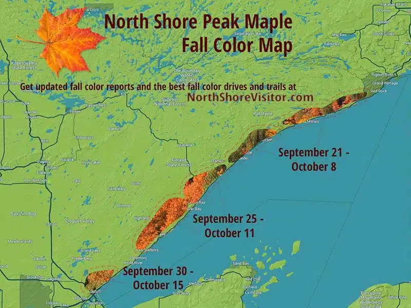
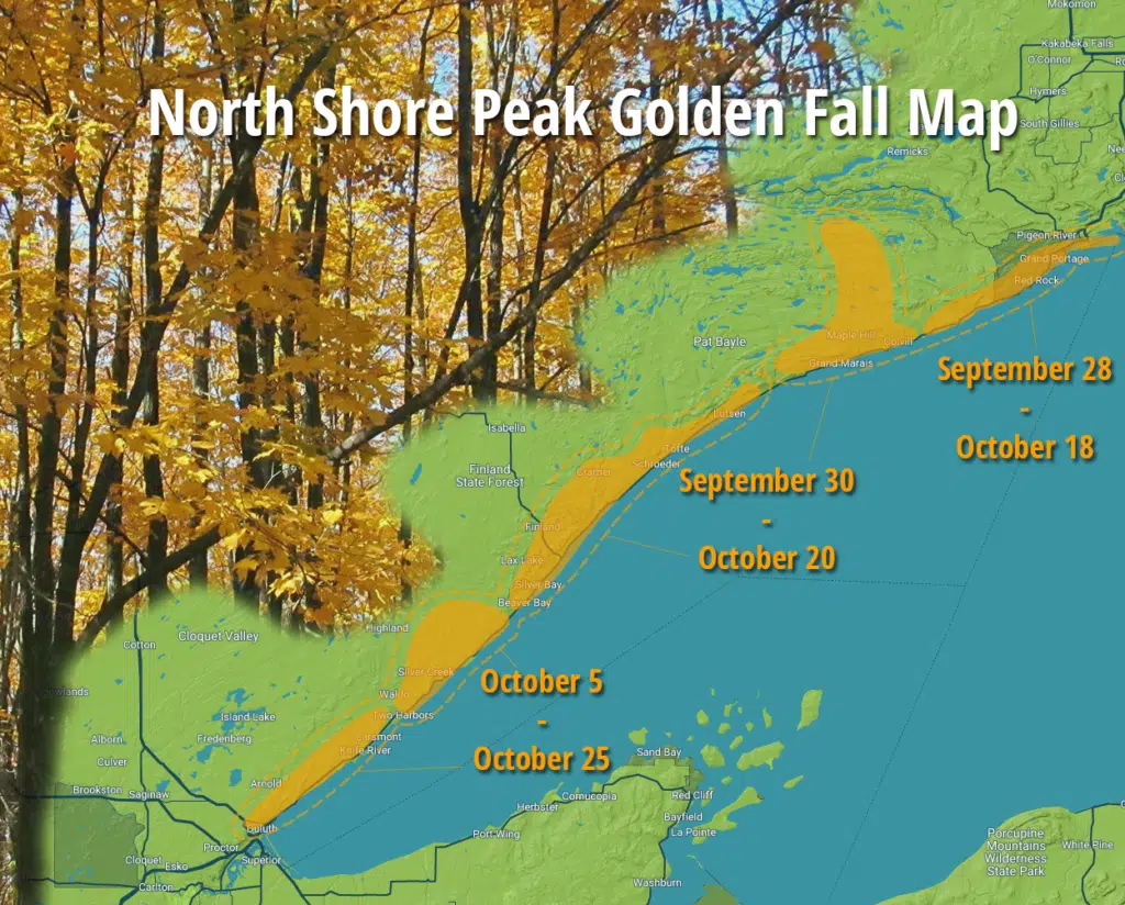
north shore fall colors
Autumn on the north shore is glorious. Nights cool down making for crisp mornings and warm days. As days shorten, leaves quit producing chlorophyll and the latent colors – red, orange, burgundy, yellow, gold – emerge. Weather has a major impact on the colors of the season – if the trees have been stressed due to lack of rain or a cold summer, colors can be subdues and the season short.Â
Typically maples begin to turn along the ridge lines a few miles inland after Labor Day by the third week/ end of September maple colors are at their peak. About this time the birch and poplar closer to Lake Superior start to run yellow and the second season starts.
Any weather works for viewing fall colors. On grey, misty days, the colors vibrate while the contrast of bright blue on a sunny day can be glorious. Plan on layering clothes to offset cool morning [upper 30s to 40s].Â
Venture out by foot, by car, by bike, or by boat. The choice is yours and the rewards are spectacular. Maple fall colors cannot typically be seen from the lakeshore; they require the warmer inland temperatures of the valleys and south-facing secondary hillsides.
Fore better viewing, travel with the sun at your back – to the west in the morning and to the east in the afternoon.Â
Here are my recommendations for the best fall color routes on Minnesota’s North Shore of Lake Superior.
This route explores the backcountry including northern hardwood forests of oak, maple and basswood and boreal forests of pine, spruce, cedar, aspen and birch. It’s a great way to get off the highway and go for a country drive – all paved roads. From Two Harbors, drive northeast on MN-61 to Lake County 3, stay on this road – it turns into the Airport Road – until the T and head south on the Lax Lake Rd to Beaver Bay.
Consider continuing behind the ridge line by heading north on the Lax Lake Rd and following the directions of the Beaver Bay to Illgen City route.
31.9 miles to Beaver Bay and 25 miles return on Highway 61 to Two Harbors
Short, steep and so worth it, this trail ascends out of the parking lot. After a series of switchbacks, the trail parallels the ridge and rewards you with a Lake Superior view. Continue on to Wolf Rock for amazing wide-open vistas of the lake. Continue on to Gooseberry Falls State Park, or turn around, enjoy the descent and head to your next short hike!
Length: 9.4 miles one-way to Gooseberry Falls State Park
Difficulty: moderate [climb 472′ (217′ to Wolf Rock), descend 689′]
While the fifth falls is the smallest waterfall at Gooseberry Falls State Park, it is a nice walk through the woods through the woods. The Fifth Falls Trail runs north along the east side of the meandering river slowly climbing to the base of the falls. The path leads up across the river to a nice scenic overlook before returning south, and downhill, along the west side of the river in a mile loop. In the winter, a there-and-back cross-country ski trail leads to the same falls and scenic overlook.
Amenities:Â Visitor center has restrooms, and during open hours a gift shop and exhibits
Length: 2+ miles
Difficulty: easy, partially paved
Take the easy accessible trail to the Visitor Center stairs to the Lighthouse. Then descend cliffside steps to Lake Superior and the Pump House. Trails traverse cobblestones beaches and adjacent forests; giving way to vantage points for viewing lighthouse. The Merrill Logging Trails crosses Highway 61 and meanders through the northern park forests. In winter 8.7 miles of multi-use trail with tracks for classic cross-country skiing on one side and the remainder of the trail for fat bikes, snowshoes, hiking, and skate-skiing are available. This provides a unique opportunity for people with different interests to all share the same trail.
Amenities: outhouses, some paved trails, picnic areas, visitor center
Length: 12 miles total with 3 along the lakeshore
Difficulty: easy to moderate
This route explores the backcountry including northern hardwood forests of oak, maple, and basswood, and boreal forests of pine, spruce, cedar, aspen and birch. You will ascend to the top of the hills, then drop down for a woodland drive. Watch for deer – and maybe a rare moose – on this winding, low-traffic road. I suggest starting in Beaver Bay and working counterclockwise so you can enjoy the views descending MN Highway 1 towards Lake Superior and Highway 61.
This drive is lovely anytime during the season, showcasing ridge line maples early and poplar and birch later.
Option:Â at MN Hwy 1, turn left and go to Finland for a visit and lunch; return on MN Hwy 1, or on Co Rd 6, where the final few miles of descent are also impressive. All roads are paved. Click on the map for a larger
Great variety of trails; meander easier trails near the visitor center, or drive in to the park and spend a day [or more] exploring; follow the Superior Hiking Trail west from the campground for overlooks, then head north and traverse around Mic Mac and Nipisquit lakes before returning. See below for details on hiking to the waterfalls and from the Lax Lake Road trailhead.
**note the trail from the visitor center area to the falls has a lot of steps, so not the best for those with knee issues; instead, consider parking at the Superior Hiking Trail trailhead on Hwy 1 and hiking in [still some steps]
Amenities: picnic areas, visitor center
Length: 23 miles
Difficulty: some easy, more moderate to most difficult due to steps and rise in elevation
Trailheads: at Visitor Center, at Campground & on Lax Lake Road
One of my favorite medium hikes! The Tettegouche Lake loop is part of a trail system accessed on the back side of Tettegouche State Park. It begins with an old road bed climbing 285-feet over three-quarters of a mile, includes four overlooks and a dip down to the historic Tettegouche Camp [where cabins are available for rent]. I like to go counter clockwise from the junction and see the overlooks, then take a little break at the Camp where I decide if I am going to add on more loops or head back. In the autumn, consider the ‘circling the lakes’ as the valleys are filled with colorful maples!
Length: 3.5 miles
Difficulty: moderate to difficult due to hills
Driving directions can be funky: from Highway 61, drive north on MN 1 for 4.3 miles, turn left on Lax Lake Rd for 3.1 miles, parking will be on left.
This hike is fantastic during fall colors, and great in the spring before the leaves pop. You will hike inland a mile, climbing in elevation. About the time you want to take a breather, there’s an overlook of Lake Superior – nice, but nothing compared to the view from the spur trail you take to the north. This narrow, windy trail can be slippery when wet, especially on the bare rock portions of the trail. The first overlook is outstanding, with 270-degree views all along the shore and inland.
Continue on around the exposed knoll to the north. After a short jaunt through pretty woods, you come to a northern overlook which overlooks distant maples hillsides while at your feet, the cliff drops away to a slough; breathtaking.
Length: 3 miles
Difficulty: moderate, steep and in inclement weather difficult due to exposed slippery rock
Hike through boreal forests before climbing maple ridges that showcase magnificent fall colors and impressive rock cliffs with view to the Baptism River valley. The trail is 4.5-mile round trip.
From Highway 61, drive north on Lake County Road 6 for for 2 miles to the Superior Hiking Trail sign and parking.
*Bonus: on the drive back down Co. Rd 6, stop on the southbound gravel pull off just before the guard rail starts, for an excellent view of the big lake.
Make this fall color tour drive number one your list. It is breathtaking. The short drive leads you down one of the prettiest maple canopied drives along Minnesota’s North Shore. A roadside plaque explains how Heartbreak Ridge was named. The final descent into Tofte offers a glimpse of the Tofte cemetery and views of Lake Superior. The Sawbill and Hwy 61 are paved; the other roads are gravel. 18 miles total
If you’re willing to hike up a hill, you’ll be rewarded with views of the maple and pine covered hills rolling down to Lake Superior, which stretches for miles to the south. Hike under maple and birch canopy before stepping out on a large basalt overlook.
The trailhead is the hub for many hiking options: east to LeVeaux Mountain, west across the Sawbill Trail to the top of Carlton Peak, adjacent mountain cross-country ski trails, and/or bring your bike for the single track trails.
Length: 0.5 miles
Difficulty: moderate due to steepness
Massive blocks of gray anorthosite form Carlton Peak. This heady summit gives bird’s-eye views of the maple forest you crossed to reach the peak. Carlton Peak is 924 feet high with the trail elevation of about 550 feet. A nearby overlook has panoramas of Lake Superior, Tofte, and the Temperance River Valley, which makes this a great late season hike, too.
Length: 3-3.4 miles depending if you take the spur trails
Difficulty: moderate due to steepness
While this is the trail to hike during autumn’s early season of maple colors, it is fantastic spring, summer, and winter, too. This trail begins with a spur, which connects to a loop around Oberg Mountain’s upper edge. Overlooks include views of adjacent LeVeaux Mountain, Lake Superior, the maple hillsides, and Oberg Lake. Enter the maple woods and hike under the canopy of birch and maple before you begin the 2-mile loop. Plan on a busy trail filled with happy hikers – the views will do that.
Length: 2.25 miles
Difficulty: moderate with steep climbs and open rock cliffs
Waterfalls, woods, wide-open vistas and an optional tram ride make this hike rather spectacular. For the downhill version, ride the tram over the Poplar River and up the east face of Moose Mountain. At the top, head to the chalet for 180-degree views of Lake Superior, the shoreline, and maybe on a clear, low-humidity day, the south shore of the lake.
Hill top trails [about a mile total] allow more perspectives on the lake views, and a stunning overlook gives 180-degrees northern views of maple hillsides, especially stunning in the autumn. From the top of the hill, take the Superior Hiking Trail down the ridge to the top of Mystery Mountain for another overlook, then into the woods to the falls of the Poplar River. After crossing the river, when you hit the gravel road, take it to the south to the main parking area at Papa Charlie’s at Lutsen Mountains. You can, of course, start here, hike up and hike/ride the gondola back.
You must purchase your tram ticket at the office / tickets are not sold at the Moose Mountain summit.
Length: 1.0+ if you take the gondola over; up to 12.2 mile to hike the entire loop
Difficulty: easy to difficult
A 230-foot climb in under a quarter mile brings views of Caribou Lake, and the thick maple forests surrounding it. This little hikes leads to a spur trail of the Superior Hiking Trail [SHT]. Look for the SHT trail sign on the left side of the lot, and follow the trail, which leads right to the Caribou Trail; cross the road and follow the trail to the top. This east-facing overlook makes for a pretty sunrise spot, too!
From Hwy 61, turn north on the Caribou Trail/Co Rd 4 for 4 miles to the small parking area on the left; if you come to the boat launch, you’ve gone too far.
Choose your own hike length. For a shorter jaunt with river views from above, head north 1 mile to the North Cascade River Camp. Or hike down the east side of the river a half-mile or more for picturesque riverside views of cliffs under old growth cedars.
The big loop, 6.8 miles is down the east [or west] side of the river, crossing on the footbridge and returning north. This hike has you descend just over 1000-feet and climb just over 1100-feet. A 3.6-mile option is to leave a car at the Highway 61 parking near the river mouth, then take another vehicle to the trailhead and hike downriver and downhill.
Cascade Mountain, pictured here, is visible from the parking area.
Length: 1-8.8 miles
Difficulty: moderate to difficult for length
Picturesque Maple Hill Church sits center stage surrounded by maples. This short drive is just outside Grand Marais, an easy add-on to your day, or perfect first stop on your way up the Gunflint Trail. Allow a few contemplative moments to enjoy the serene surrounding.
From the Gunflint Trail, turn west onto Maple Hill Drive for 0.6 miles. Return the same way.
The Trout Lake Road / County Rd 60 loop is a lovely drive, with beautiful sugar maple-lined sections of the road, often with their canopies meeting overhead. This is also a chance to get out into the woods from Grand Marais on an easy to navigate drive. You will head north on the Gunflint Trail, drive a loop and return on the Gunflint Trail, which, along with Hwy 61 are paved; all other roads are gravel.
From Hwy 61, drive north on Gunflint Trail for 11 miles; turn right on Trout Lake Road for 7.5 miles; turn right on County Rd 14 for 2.5 miles; take a slight right on County Rd 60 for 6.4 miles; turn left on Gunflint Trail for 4.7 miles, and, turn right on 5th Ave W for 0.7 miles.
Hiking, biking, skiing and snowshoeing making Pincushion Mountain trails the Grand Marais trail system. Close to town, lots of spur options and expansive views make this an ideal hiking location. My #1 recommendation is the hike to the summit of Pincushion Mountain, pictured here. Use the map. There are loads of intersections and it is easy to get confused. You will follow the Superior Hiking Trail on the Pincushion Loop, then take the spur trail to the the peak. You will come to an overlook — appreciate it — but keep going, the views open up to 270-degrees just a bit further along. Return on the Pincushion Loop making this a 4.5 mile hike.
The hike follows cross-country ski trails so is a nice wide trail through birch with some low areas, moderate ascents and nice pines. Hike the 25K of cross country ski trails or the new bike trails (give right away to bikers, though!). The Superior Hiking Trail also crosses through the trail system and the overlook offers panoramic views of Lake Superior and Grand Marais. Trails have lots of junctions, so consider bringing a print map.
Mountain Biking
Seven narrow hard-pack trails intersect and climb the wooded hilltop overlooking Grand Marais and Lake Superior. The easy Pincushion Mountain Loop includes a small spur hiking trail to the summit. Test your skills on the advanced loops which connect to the intermediate loops.
Length: varies, 4.75 miles for Pincushion Mtn loop and spur to summit; 20 miles of bike trails
Difficulty: easy to more difficult due to length
Surface: hard pack and rock
Take a late season fall color drive in the back country. From the Gunflint Trail, drive west on Forest Road 325 / South Brule Road for 6 miles, drive north on on the Lima Grade for 9 miles back to the Gunflint Trail, either continue up the Trail [7 miles to mid Trail forr a few shops and restaurants] or return the approximate 28 miles to Grand Marais
*Bonus Hike:
At about 3.4 miles up the Lima Mountain Grade, you will see a grassy parking area. A rocky, poorly maintained trail leads about 1.2 miles to the top of Lima Mountain, where a fire lookout tower once stood [erected in 1935 and removed in 1978]. You will also get great views of the golden backcountry from an overlook about 2/3-mile in; return the same way.
Beautiful sunsets, big views, wooden stairs and a rocky overlook make this a great hike. At 1.5 miles round-trip, it is the longest of the short hikes and very worth it. Take the spur trail in and then start to climb those stairs. Your reward, amazing views of Hungry Jack and Bearskin Lakes, and out into the Boundary Waters Canoe Area Wilderness. If you go for the sunsets, bring a headlamp, flashlight, phone light for the return trip. Talk about bang for your buck!
The Trailhead is about a quarter mile past Flour Lake Campground Rd.
Length: 1.5 mile total
Difficulty: moderate [steep]
The tower overlooks sugar maples, quaking aspens and conifers, making it a good drive and hike all fall color season long. This is a good wildlife viewing spot.
From mile marker 128.7 on Hwy 61 in Hovland, turn north on Arrowhead Trail for 3.7 miles, then park on the side of the road [leaving room for other traffic] and hike 1.5 miles west on the Superior Hiking Trail. Return for a 3-mile overall hike.
**Note: the Superior Hiking Trail Parking trailhead is 3.3 miles north on Arrowhead Trail; hiking from here increases the hike length to about 4 miles.
The Mount Josephine Wayside Rest has a spectacular overlook with views of the Susie Islands below in Lake Superior and Isle Royale in the distance. Isle Royale National Park is part of Michigan. The area is open April through October, has picnic tables and outhouses, and is located on the lake side of Highway 61.
upcoming events
- Now that summer has ended: An exhibit about winter at Grand Portage during the fur trade Era
- March 15, 2023 - May 26, 2023
- Two Harbors Mixed Spiel
- March 24, 2023 - March 26, 2023
- Northern Lights Forecast
- March 24, 2023 - March 26, 2023
- Live Music at Papa Charlies
- March 25, 2023
- Hannah Rey at Ledge Rock Grille
- March 25, 2023
- see all events