
north shore trail, activity and general maps
for places along minnesota’s north shore of lake superior
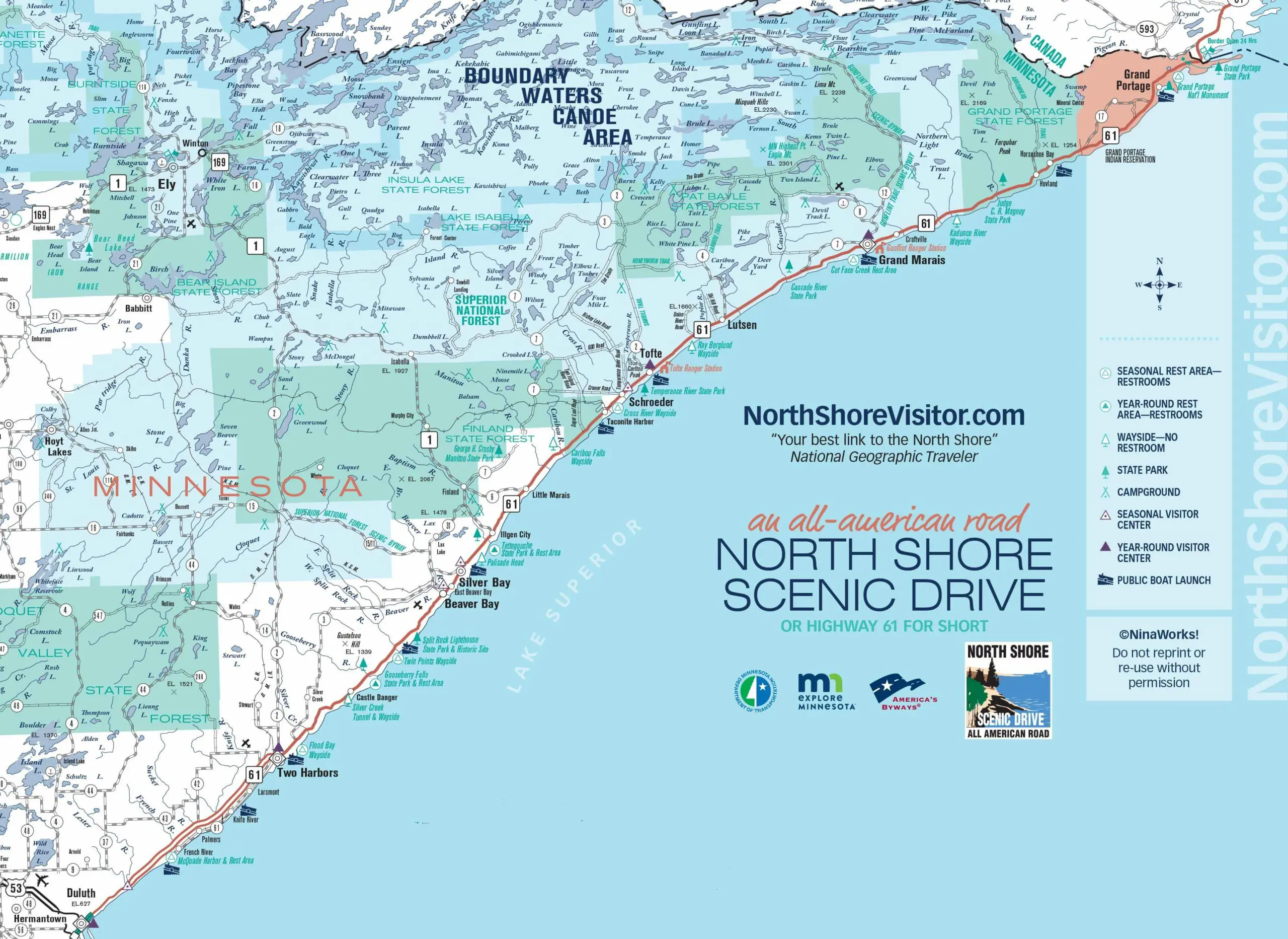
Do you like a good visual? Want a map to show you the lay of the land? We’ve got that for you. We have maps for hiking, biking, climbing, camping, the Superior Hiking Trail, the Gitchi-Gami State trail [paved], cross-country skiing, alpine skiing and snowboarding, snowmobiling, snowshoeing and fat bike trails. Plus a full map of the image above, from Duluth to the Canadian border.
From Duluth’s Canal Park, northeast for 154 miles to Grand Portage and the border with Canada, this singular drive is a voyage through some of America’s most unspoiled lands. Your route offers breathtaking views, endless opportunities to enjoy nature, historic sites, attractions, parks, and villages with events, shopping, lodging, dining, and local culture.
The path hugs the water’s edge along the inland coast of the world’s largest freshwater lake, bisecting the shore and the ancient inland rock formations and wooded hills rising above the coast. The North Shore Scenic Drive was recognized for the outstanding scenic and recreational opportunities it provides along the touted North Shore of Lake Superior and was designated as an All-American Road, Minnesota’s only such designation.
Here it is – an easy way to find every type of North Shore map we offer. Maps are listed mile-by-mile southwest [Duluth] to northeast [Canada]. Choose by activity and by location.
Watch for varying speed limits along Highway 61 – it varies from 55 mph to 65 mph plus slow areas outside of towns and state parks

2022 highway 61 road construction
New bridges northeast of Two Harbors
Construction at Silver Creek will resume on May 16, 2022. Traffic on Hwy 61 will continue on the temporary bypass at Silver Creek through fall 2022. The bypass carries northbound and southbound traffic on 11’ driving lanes. No bike or pedestrian access through the construction zone.
Construction at Stewart River will begin April 18, 2022. Crews will begin constructing a new bridge parallel to the historic bridge. Traffic will remain on existing Hwy 61 with 12’ lanes and no shoulders. The Kelsey Beach parking lot will be closed during construction.
Community
Map Type
mile 73.3
mile 78.8
mile 80.4
mile 80.4
mile 80.4
mile 82.2
mile 82.4
mile 82.5
mile 83.4
mile 84.2
Hiking Trail & Access Map
mile 86.1
mile 92.8
upcoming events
- George Morrison “Connections” Exhibit
- April 18, 2022 - September 30, 2022
- Grand Marais Art Colony June courses
- June 1, 2022 - June 30, 2022
- North House Folk School June Courses
- June 1, 2022 - June 30, 2022
- Steve Simmer Exhibit
- June 1, 2022 - June 30, 2022
- Sailing on the Hjørdis
- June 1, 2022 - August 31, 2022
- see all events