
Grand Portage State Park
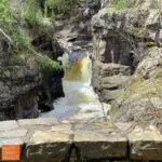
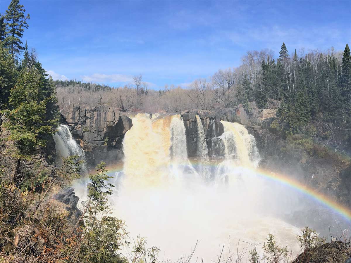
The Grand Portage Band of Ojibwe share their land at this Minnesota’s State Park. The desire for a safe approach to the 120-foot High Falls of the Pigeon River brought about this unique cooperative effort between the state and the Band. This is the only park in the nation that is managed in partnership with a local Native American band. The result is access for everyone to one of the area’s most impressive natural features.
In addition to the High Falls, the park features a lovely visitor center with natural and cultural displays, restrooms and an excellent gift shop, hiking trails, the Pigeon River and snowshoeing. No campgrounds at this park.
Park Overview
mile 150.3
Â
Open 10am-3pm year round with extended hours in the summer; offers Anishinaabe cultural and natural displays, restrooms, vending machines and a small gift shop. Excellent selection of books, some toys, naturalist items, clothing and gifts. Entry to the center has Anisshinaabe/English podiums.
After snowshoeing or winter hikes, head into the visitor center to warm up.
Access to Grand Portage State Park is Free!
State Park Vehicle Permits are NOT required at this park.
Â
9393 MN 61 | Grand Portage
218-877-8630
Grand Portage Area Lodging
mile 118.6
Â
The Our post Motel has knotty pine walls, hardwood floors, and beautiful views of Lake Superior give your motel room or fully-equipped kitchenette suite the warm feel of a cabin on the lake. Hike from your room to the Superior Hiking Trail, Kadunce River Wayside Park, or along Lake Superior’s shore. Picnic and playground area. Free WiFi. All units are smoke-free.
Â
2935 East Minnesota 61 | Grand Marais
888-380-1833
mile 118.6
Â
Among Grand Marais motels, The Outpost is a favorite. Knotty pine walls, hardwood floors, and beautiful views of Lake Superior give your motel room or fully-equipped kitchenette suite the warm feel of a cabin on the lake.
Hike from your room to the Superior Hiking Trail, Kadunce River Wayside Park, or along Lake Superior’s shore. Picnic and playground area. Free WiFi. All units are smoke-free.
Â
2935 East Minnesota 61 | Grand Marais
888-380-1833
mile 123.8
State Park Campground
This Minnesota State Park campground features:
27 seasonal semi-secluded drive-in sites, no electric sites, 45' RV length limit, 30-50 foot parking spurs.
Seasonal accessible showers and flush toilets, and vault toilets open year round.
Firewood for sale seasonally at office.
2023 payment update for camping and firewood
Reservations
Â
4051 East Highway 61 | Grand Marais
866-857-2757
mile 124.1
On Lake Superior, historic 1920s lodge and wonderful grounds abutting the Brule River and Lake Superior; great restaurant open May into October and winter weekends. 15 miles northeast of Grand Marais on Highway 61.
Â
20 Naniboujou Trail | Grand Marais
218-387-2688
mile 143.9 + 0.2 miles
Â
Grand Portage Lodge & Casino is your great north shore getaway! Located on scenic Highway 61 with breathtaking views of the Lake Superior shoreline and rolling, wooded hills. Relax in the renovated lodge, play in the new casino and enjoy delicious comfort food in Island View Dining Room!
Â
70 Casino Drive | Grand Portage
800-543-1384
Spring, Summer, Fall Activities
On the US/Canadian border, the Pigeon River drops 950 feet ending with the 120-foot drop High Falls, the highest you will find on the North Shore. This lower reach is particularly rugged until a short distance after the falls, where the river widens. An easy half-mile trail in Grand Portage State Park leads to the High Falls. The trail ends with two great viewing decks where you can feel the spray of the falls!
The former site of the lookout tower overlooks sugar maples, quaking aspens and conifers, making it a good drive and hike all fall color season long. This is a good wildlife viewing spot.
From mile marker 128.7 on Hwy 61 in Hovland, turn north on Arrowhead Trail for 3.7 miles, then park on the side of the road [leaving room for other traffic] and hike 1.5 miles west on the Superior Hiking Trail. Return for a 3-mile overall hike.
**Note: the Superior Hiking Trail Parking trailhead is 3.3 miles north on Arrowhead Trail; hiking from here increases the hike length to about 4 miles.
The Mount Josephine Wayside Rest has a spectacular overlook with views of the Susie Islands below in Lake Superior and Isle Royale in the distance. Isle Royale National Park is part of Michigan. The area is open April through October, has picnic tables and outhouses, and is located on the lake side of Highway 61.
mile 144.8 + 0.9 miles
Learn Aniishinaabe art, culture and history. Directions: from Highway 61 MM 143.3 turn right onto Mile Creek Rd, and at the first cross street, turn left and continue 0.7 miles on Mile Creek Rd.
Â
170 Mile Creek Road | Grand Portage
218-475-0123
Winter Activities
This is such a great snowshoe hike! You can walk up the frozen river which gives you the opportunity to be in the river gorge looking up the canyon walls, and come right up to the waterfalls and cascades. The Superior Hiking Trail runs to the east of the river if that’s your preference. Or you can step off the river about a third-mile in and return on the hiking trail. Be sure to look for tracks in the snow – hares, voles and even an otter slide, pictured here.
The super popular Devil’s Kettle Trail runs atop cliffs running riverside above the Brule River and ends with a loooong staircase down to the base of the Lower Falls before a short climb to view the split in the river. The eastern flow tumbles over the High Falls while the western arm drops into the Devil’s Kettle, final destination unknown.
From the parking area, the easy flat Timberdoodle Trail meanders through the woods for a mile while the 2+-mile Gauthier Creek rises over hills and takes you into this picturesque waterway. Perfect if you’re looking for somewhere to snowshoe that is infrequented.
Length: 2.25 miles Devil’s Kettle; 1-mile Timberdoodle; 2+ miles Gauthier Creek
Difficulty: easy to moderate; Devil’s Kettle includes about 200 stairs
Miles of scenic trails traverse the hilly terrain rising north from Lake Superior. The two main trail centers are located at Grand Portage Lodge & Casino and at Mineral Center (from Hwy 61, drive north on Mineral Center Rd / Co. Rd. 17 for about 5 miles to the trail center. Trails criss-cross the back country with one trail leading to Ryden’s Border Store & Gas Station on the US / Canada border.
Length:Â 100+ miles
It’s all about hiking to the 120-foot High Falls, but leave time for the exhibits, gift shop, and interpretive signs in and around the Visitor Center, where you can learn about the culture and traditions of the Grand Portage Ojibwe people. Bring your camera.
Access to grand portage state park is free!
State Park Vehicle Permits are NOT required at this park.
Length:Â 1 mile High Falls, 3.5 miles Middle Falls
Amenities:Â restrooms, water, exhibits and gift shop at Visitor Center