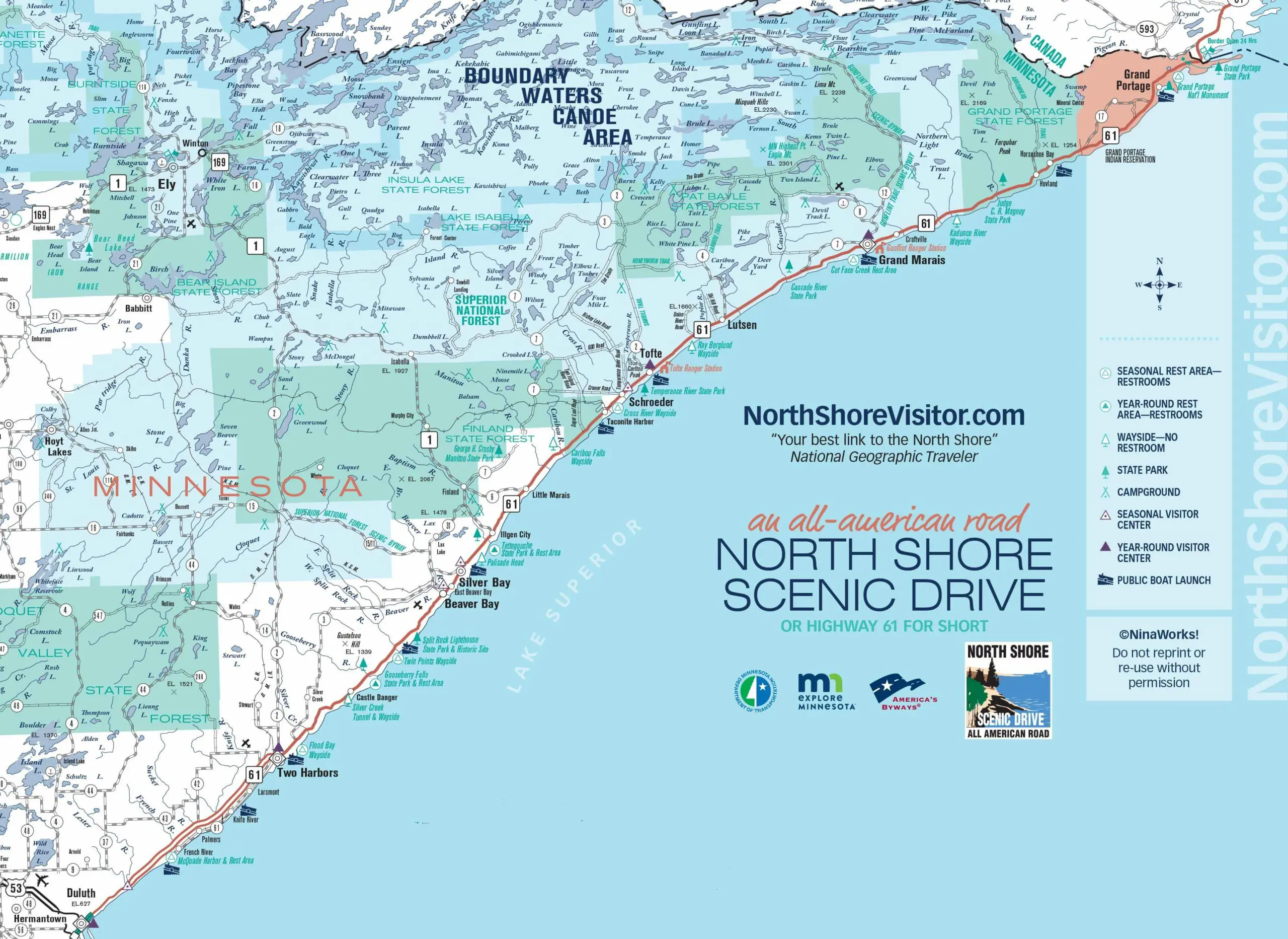
Minnesota State Parks along the North Shore
From Gooseberry to Grand Portage, the eight State Parks are quintessential North Shore. The parks encompass some of the the most striking natural resources in the area. Stop at as many State Parks as you can. It is the most delightful, and easiest way to explore the shore. The parks are listed southwest [closest to Duluth] to northeast, ending at the border with Canada.
> Minnesota state parks are open for outdoor recreation. Visitor centers/nature stores are closed until further notice.
If you do go to state parks, practice social distancing at all times, including outdoors. Be extra careful in parking areas, around signs and toilets, and on narrow trails, fishing piers and bridges where people tend to cluster.
Many parks are extremely busy every day. If you see a lot of cars in the parking lot or at the trailhead, turn around and find someplace else for outdoor recreation. Be prepared. Bring your own water, soap, hand sanitizer, disinfectants, towels and toilet paper.
Avoid crowds at self-pay kiosks: buy your vehicle permit from home. Just be sure to record your receipt number and place it on your dashboard.
Waterfalls, river, forest and Lake Superior shoreline with access to all via hiking, walking [accessible], and cross-country ski trails plus it is an end point of the Gitchi Gami paved bike trail and has access to the state snowmobile trail. Other highlights include Civilian Conservation Corps buildings, a great visitor center, and it is a state wayside rest area so free parking at the Visitor Center.
Obviously it’s all about the lighthouse! The MN Historical Center runs a great visitor center with exhibits, tours and a short film. The state park is all the land surrounding the lighthouse and has great hiking trails, a covered picnic pavilion, and in the winter the trails are dedicated to Fat Bikes.
Lakeside, riverside, inland lakes, waterfalls and hikes along Lake Superior up, up, up along the river and adjoining forest lands. Plus an extra cool historic camp with cabin rental available.
Where to go for peace and quiet. This park is 14 miles off Highway 61 and surrounds the Manitou river with hiking, rustic hike-in campsites and picnicking.
Amazing river gorges that start a few feet inland from the highway, waterfalls, two foot bridges, hiking, a cobblestone river mouth, camping and hiking.
Excellent hiking and cross country ski trails plus trails that climb Lookout Mountain, a quick 1/4-mile loop up and over the river from the highway, and the cascades that are the namesake of the river.
Another quiet state park, but with easier access. Home to the Devil’s Kettle, the cauldron that gulps up half the river and takes it to an unknown destination. Hike alongside and high above the river along a great hiking trail [lots of steps though!].
Highest waterfall partially in MN, it plunges 120-feet down the international border river, Pigeon River. Fabulous visitor center introduces and share the local Aniishinaabe culture. Yes, you can see Canada from here.
Questions? Scroll down to learn about what permits are required, where, when and how you can include your pet, camping and firewood details, what you need to know about fishing, and about cross-country ski and snowmobile trails and licenses. Click on each park to get an overview of what it has to offer and specifics about visitor center hours and amenities, maps, historic sites, waterfalls, and recreational opportunities.